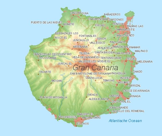
Tourist map Gran Canaria (clickable)

 Culture Culture Nature Nature Religion Religion Archt. Archt. Museum Museum Activity Activity Am. Park Am. Park |

|
1

Las Palmas de Gran Canaria
: This large city includes a nice cathedral and the Casa de Colon.2

Dunas de Maspalomas
: These walking dunes in the south of Gran Canaria are more than worth a visit.3

Pozo de las Nieves
: The highest mountain of the island is 1949 meters high and reaches from Ayacata. At the top provides a magnificent view over the island.4

Aqualand
: Waterpark for the whole family in Maspalomas in the south of Gran Canaria.General Information Gran Canaria
| Population: | 855.521 (40,6%, 2e) |
| Density (people/km2): | 548 (1e) |
| Area (km2): | 1560 (20,9%, 3e) |
| Main cities: | Arucas, Telde, Santa Lucía de Tirajana |
| Sun hours in winter: | 6 |
| Sun hours in summer: | 9 |
| Tourism (%): | 26,1 (2e) |
| Bed places per km2: | 91,3 (1e) |
| Landscape: | volcano landscape |
| Highest elevation point: | Pico de Las Nieves 1.949 meter |
News from Gran Canaria.
Spanish news
Expats
Expatriate in Spain
Youtube Gran Canaria video - motion pictures
Land use Gran Canaria
|
Climate: Mean temperature (�C) and Precipitaion (mm)
Weather forecast
Weather Las Palmas De Gran Canaria
On holiday to Gran Canaria
Touristic information Gran Canaria
Official website government of Gran CanariaReal estate in Gran Canaria
Accomodation in Gran Canaria (holiday-homes, hotels and campings)
Experiences Gran Canaria
Pictures, maps and articles of Gran Canaria
1) Photos (Flickr) of the autonomous community - province Gran Canaria
2)
 This area in Google Maps
3)
 This area in Wikipedia Gran Canaria (for workpiece or speech)
4) Translated Spanish wikipedia Gran Canaria
Social Media
Instagram SpainThe weather and climate
Current weather in Gran_Canaria_Canary_Islands (temperature, precipitation).Weather forecast


